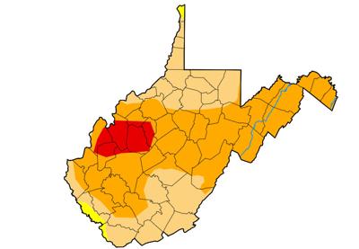
This map shows West Virginia’s areas of extreme drought (red areas) and severe drought (dark orange areas).
NOAA graphic
Moderate to extreme drought is occurring across 98.53% of the state’s land mass, according to the NOAA program, with the remaining 1.47% of the state listed as “abnormally dry.”
Wyoming comes in a close second, with 96.38% of that state’s terrain experiencing moderate to severe drought, but none of its territory is dry enough to make the “extreme” category.
Closer to home, about 35% of Virginia and Ohio are experiencing moderate to extreme drought, according to Drought Monitor.
In West Virginia, the most extremely drought-parched portion has shifted from the state’s Eastern Panhandle to a strip of west-central counties, including the extreme north end of Kanawha, nearly all of Roane, and parts of Jackson, Calhoun, Putnam, Mason and Wirt counties.
Extreme drought is occurring across 6.6% of the state’s terrain, according to the Drought Monitor, while severe drought is present across 56.3% of the state, and moderate drought can be found on 35.6% of the West Virginia landscape.
July was the state’s eighth-driest since 1900, according to NOAA.
West Virginia’s most severe drought on record took place in 1930-31, when nearly 100% of the state experienced what is now characterized as an “exceptional” drought for eight months.
Kanawha Metro-area forecast
Dry, sunny weather is expected to prevail across the Charleston-Huntington area at least into the middle of next week, according to the National Weather Service. After starting the week in the 70s, temperatures are expected to rise into the low 80s on Thursday, upper 80s on Friday, and then return to the 90s Saturday through next Wednesday.
While the Eastern Panhandle got some relief in the form of rainfall recently, “We’re not going to see rain around here for a while — at least for the next week or so,” said Chris Dickman, meteorologist with the National Weather Service’s Charleston Forecast Office.
CLICK HERE to follow the Charleston Gazette-Mail and receive