Sunshine and clouds mixed. A stray shower or thunderstorm is possible. High 79F. Winds SSW at 5 to 10 mph..
Tonight
Partly cloudy this evening followed by increasing clouds with showers developing after midnight. Low around 65F. Winds light and variable. Chance of rain 40%.
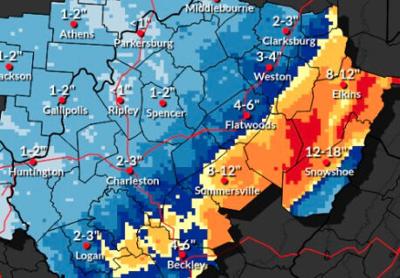
A winter storm warning is in effect for much of West Virginia through 1 a.m. on Feb. 24, 2026.
National Weather Service | Courtesy image
Several inches of snow is likely headed toward the Charleston area by Monday evening, with much more in the eastern highlands of West Virginia.
Charleston is expected to see less, about 2-3 inches of this snow from this storm, which might do its biggest damage in the northeast corridor around New York City on Monday, according to the National Weather Service in Charleston, has issued a winter storm warning through 1 a.m. Tuesday for much of West Virginia.
Accumulations are expected to begin Sunday night in Charleston.
Areas from Logan to Clarksburg along the Corridor G and Interstate 79 corridors should expect several inches of snow with much more falling in the eastern highlands. Snowshoe in Pocahontas County could get more than a foot of snow.
Roads, especially bridges and overpasses, will likely become slick and hazardous. Whiteout conditions are expected and will make travel treacherous and potentially life-threatening.
The hazardous conditions could impact the Monday morning and evening commutes.
Here’s the forecast through Tuesday, according to the National Weather Service in Charleston.
Sunday: Snow after 3 p.m. with gusty wind. High near 36. Chance of precipitation is 80%. Daytime accumulation of 1-2 inches possible.
Sunday night: Snow, with a low of 24. New snow accumulation of less than 1 inch possible.
Monday: Snow likely between 7 a.m.-1 p.m. Chance of precipitation is 70%. Look for a high of 34 and a low of 25. Little new snow accumulation expected.