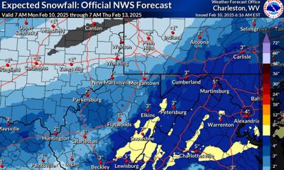
This map shows the snowfall forecast for West Virginia for Feb. 11-12, 2025, as of 6 a.m. Monday, according to the National Weather Service in Charleston.
This map shows the snowfall forecast for West Virginia for Feb. 11-12, 2025, as of 6 a.m. Monday, according to the National Weather Service in Charleston.
Courtesy photo
More winter weather is headed our way, with rain, freezing rain or several inches of snow possible Tuesday for the Charleston area, depending on how a cold front moves through the area. The eastern mountains could see as much as 7 inches of new snow.
A Winter Storm Watch is in effect from 4 a.m. Tuesday through 11 a.m. Wednesday for much of West Virginia, according to the National Weather Service in Charleston.
The hazardous conditions could impact the Tuesday morning and evening commutes.
Get up-to-the minute road conditions in West Virginia provided by the state Department of Transportation. Call 511 or online at wv511.org.
Weather forecast
On Tuesday, look for snow before 10 a.m., then rain and snow. Tuesday’s high will be 36, according to the NWS. Two to 4 inches of snow accumulation in Charleston is possible.
But depending on where the warm air sets up, we could see more snow or less, and more rain/freezing rain, according to the NWS.
Wednesday will warm to near 49, with rain in the afternoon into Thursday. According to the NWS, there are increasing chances of flooding due to heavy rain, saturated soil and melting snow runoff.
West Virginia Department of Transportation encourages all motorists to use extreme caution on the roads as West Virginia Division of Highways crews work to keep them clear.
“We’ll be out doing some pre-treating with brine around the state tonight and are prepared to work around the clock even before the snow starts to fall,” said Jacob Bumgarner, chief engineer of special programs and acting chief engineer of district operations. “The effectiveness of what we do will hopefully be seen because of the temperature staying right around freezing or a little above it, which is not what we saw with the last winter storm.”
Appalachian Power’s Storm Response Team is monitoring the weather forecast. If the weather turns to freezing rain, ice accumulations over a quarter inch weigh down trees and electric lines, which can cause substantial utility problems.
In anticipation of the approaching storm, all company crews and contractors are stationed in their respective areas, fully packed and ready to respond to outages.
Additionally, Appalachian Power has requested 600 line mechanic personnel and 100 assessors from neighboring utilities. These additional crews are expected to be in its service territory later today and ready to assist with storm restoration as early as tomorrow morning.
How customers can prepare
Charge phones, laptops and other electronic devices.
Prepare an emergency kit with non-perishable food, water, flashlights, batteries and a first aid kit.
Make a plan in case of extended outages, especially those requiring electricity for medical equipment.
If you have a generator, be sure you have read all the manufacturer’s instructions.
Download Appalachian Power’s mobile app and sign up for Outage Alerts for outage updates.
After a quiet start to the work week, a complex weather system will arrive late tonight and promote a variety of hazardous weather concerns from Tuesday through Thursday. A combination of snow, rain, and freezing rain is expected for Tuesday into Wednesday. pic.twitter.com/jg23ybnuOf